Modelling
Modern model system nowadays are almost able to rebuild
nature within the computer.
HYDROMOD provides a wide spectrum
of methods, techniques and models which can be used for both
quiet lakes and flowing rivers.
Depending on the tasks to be
solved the river or lake will
be described by a set of
hydrophysical equations, boundary
conditions and a spatial computational
grid on which the afore mentioned equations
will be solved. These highly
complex simulation model systems
are processed on powerful computers and must be calibrated
and validated with measuring
data which have to be gained
at selected positions within
the model area.
After the successful validation the model system is able
to provide forecasting computations for selected special
scenarios.
|
|
Click
to enlarge!
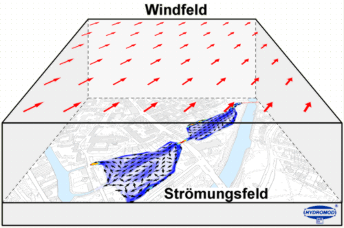
Figure: Snapshot
of the surface current pattern
within Krähen- and Mühlenteich
controlled by the amount of inflowing
water and modified by a variable
wind field. |
To run a numeric simulation model a number of boundary conditions
have to be defined. Apart
from the general needed bathymetric data the meteorological input
(wind field, air temperature,
air pressure, solar radiation,
etc.) as driving force is of great importance. For the Mühlen-
and Krähenteich model system
additionally variable in-
and outflow volumes where used to control and modify the model
results.
|
|
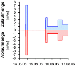
 |
Time
series in- and outflow
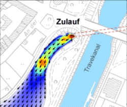
|
Current
pattern in- and outflow area. |
next ...