|
|
 Deutsch Deutsch
A core area of HYDROMOD's work is the numerical modelling of diverse waters, as well as the illustration of variants of planned or unexpectedly occured changes by computer animation. In this way measurements can be planned precisely and optimised and possible negative impacts can be minimized.
|

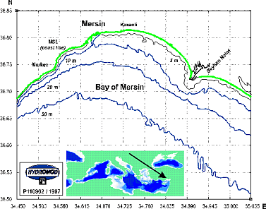
above: The Bay of Mersin - investigation area for a feasibility study, model calculations, environmental impact assessment, and risk analysis of existing and planned marine outfalls for treated and untreated sewage water.
|
Distribution of a waste water plume after 48 hours of simulation time in different diffuser depths (22 m and 32 m depth)
|
|
|
The results of the following HYDROMOD models can be used to simulate and forecast, for example, circulation patterns, dispersion of a variety of substances, and turbulent processes.
Information resulting from these models can be utilised for a wide range of applications in operation, supervision, and control:
- 1-, 2- and 3-dimensional circulation models for rivers, lakes, estuaries, coastal waters, shelf seas and the open sea
- Operational now- and forecast model systems which can be inter-connected with monitoring networks
- Water information systems
- Turbulence models
- Tidal models
- Hazard prediction models
- Water quality models
- Ecological models
- Dam breaking models
- Water network models
- Groundwater models
- Digital elevation models
- Simulation models of outfalls, intakes, advection, and diffusion like drifting objects, oil and hydrocarbons, water ingredients, pollutants, waste water, cooling water, nutrients, sediment, and suspended matter
- Storm prediction models
- Local weather models
|
|

